Friday, September 8, 2017

Seafood, volcanoes, sand dunes, latinos, beachs, dolphins, and a Toyota pickup photo shoot


2014:

For Julie's birthday, we headed down the Baja peninsula of Mexico with no agenda only a sense of adventure. We knew we wanted to head south, and what better place to knock some of the rust off of our Spanish skills than Mexico. I recently acquired the Toyota pickup truck and it made for great transportation and camping. Everybody we met was friendly and inviting, and surprised to see 2 gringas cruising alone. I feel that once you pass Tijuana, or most of the border towns, Mexico is a fairly safe and inviting place. It was nice to munch down on Mexican food all the time, and have cheap accessibility to all those yummy Mexican snacks. The trip was a great success. 


The sand dunes and the stray dog with Juie


The gorgeous coast near Ensenada: our first camping spot

The volcano in the National Park at sunset

Our camping truck for this Baja excursion, I named her Relampago Dorado - Golden Lightning

Losing a finger while climbing the Fox Glacier

Well alright, I didn't lose a finger while climbing the Fox Glacier, but it sure was a fun sketchy adventure. We were equipped with ice axes, crampons, and cold weather gear. It ended up being a beautiful day. I swear that the water coming straight off that glacier is the best water I have EVER had... I was filling my bottle up every 5 minutes. 
Beth, Julie, and I near a crevasse on Fox Glacier

So long New Zealand....


Friday, January 3, 2014

Beer and chocolate?

I liked the New Zealand city of Dunedin simply because I could enjoy two amazing things...beer and chocolate, to clarify, not chocolate beer (although that is delicious as well). The coastal city of Dunedin is home to the Cadbury World Chocolate Factory and the Speight's Brewery; the city was calling my name. 


We stopped first at the Cadbury World and got prepared to enter the Willy Wonka like place. Hair nets, no jewelry, no phones, no cameras…which is probably for the best because I don’t want to get somebody’s earring inside my Cadbury egg. Gross. We walked through and learned about the ingredients and the benefits of having arguably some of the best dairy in the world for their chocolates. We were shown the very detailed process of making bricks of baking chocolate, the cement mixers used to coat chocolate balls in different colors, and the making of the miniature candies. It was a modern day Willy Wonka, all the way down to our guide whose outfit reminded me of a purple oompa loompa. 


We were blown away by the stats of chocolate consumption our guide provided. New Zealanders eat an average of 5 kilos of chocolate per person per year, Americans are at 6, and English were at a whopping 10 kilos of chocolate per person per year! One of the coolest parts was when we entered one of the old silos, that was originally used to store milk, and saw an enormous chocolate fountain. This chocolate fountain poured a 4-foot-wide stream of liquid chocolate as a waterfall down the middle of the silo. Yummmmmy. 

Chocolate galore: Chocolate and chocolate soda 
Walk through town to the other side and you've reached the brewery, this was the best city planning ever!


This building was founded in 1876 and was currently under a major reconstruction project that was aimed to increase their production by 200%, I guess Kiwis are thirsty! So we were fortunate enough to see the older brewing sets as well as the new state-of-the-art brewing facilities, an interesting dichotomy that reminds me that beer will never go out of fashion.

The beautiful copper original brewing set


The brewery also has a museum attached to it because it has a large cultural significance for the southern island of New Zealand; known as “The Pride of the South.” A very interesting point of transition for the Speight’s beer business was the Christchurch earthquake. Kiwis drink so much that Speight’s was able to set up underground tanks throughout all of New Zealand so that liquid carrying semi-trucks would come once a week and fill up the tanks underground that had a direct line to the taps upstairs in the bar. No kegs, streamlined process. Well the 2011 earthquakes destroyed that concept when building everywhere collapsed and tanks and bar were ruined or shut down; now as part of the transition period, they changed this tank system that they’d used since the 90s and are returning to the keg (or hogshead) process. The ripple effects of their natural disasters became more and more evident as I traveled New Zealand.

Like a boss, sweet as! 


Well after the tour it was open bar and all you can drink for 30 minutes. We got to try so many different types of beer; IPA, pale ale, cider, porter, and much more. They had on tap Speight’s Gold Medal Ale (the ale that won at a world competition in Australia and put Speight’s on the map), Golden Pale Ale, Old Dark (an English Porter with hints of chocolate), Distinction Ale (an unique and delicious dark ale), Triple Hop Pilsner, Porter, and Speight’s Cider. Yummmmmy. 

As if we couldn't get enough on tour....filling up the water carrier
Kiwis and visitors alike eat lots of chocolate and drink lots of beer: reason no. 54,286 to go to New Zealand. 

One last piece of food for thought.... Happy New Year ! 


Wednesday, December 18, 2013

Hiking to Mordor


One of the things New Zealand is known for in the eyes of visitors is Lord of the Rings. I will attest that it is uncanny how many times I notice places I've been in the Lord of the Rings and Hobbit movie, its quite cool. One of the biggest draw cards is Mordor, or Mt. Ruapehu, a volcanic mountain which Peter Jackson based Mordor on. WARNING: Many Lord of the Rings references to follow, if you are annoyed with this constant reference, I wouldn't read any further. :-)

While I was on the north island of NZ,  I was passing through Lake Taupo and really wanted to hike this mountain. Unfortunately, the first time I came around with my friends from Australia, the weather was too bad to attempt the Tongariro Alpine Crossing; a hike that traverses the mars like landscape around "Mordor" and leads you to the path to climb it if you so choose. Luckily, when I revisited Lake Taupo a week or two later with my friend visiting from the states, the weather was predicted to be good even though they'd had a hail storm the day before. Well that's all I needed to hear, let's pack the bags!

The surrounding mountain range

At the beginning of the hike

The hike was estimated to be 7 hours, 19 kilometers (almost 12 miles), dropping and climbing to reach heights of 1900 meters (6,200 feet), and passed through active volcanic zones. We began by hiking by a creek which was sourced from above in the mountain, the landscape was barren, dry, and cold, as alpine as it gets. I could see other snow capped peaks in the distance, but Mt. Ruapehu remained hidden behind cloud cover. We reached the base of our first big ascent and this looked all too much like the hike Sam and Frodo did to enter up the back entrance of Mordor. OK maybe not as dramatic, but there were certainly tons and tons of stairs. So it began, step after step. Maybe I should of considered my backpack (full of water and food) to be my ring, but I certainly wasn't planning on throwing it into the volcanoes once I reached the top, so I think that would of been a stretch. The ascent up the stairs takes about 2 hours, but once at the top you are  rewarded with beautiful views of the mountain valleys, and finally the cloud hovering above Ruapehu had cleared and I could see the volcano. It was amazing how much it looked like the one in the movie, it didn't take much imagination, add a few orcs and a big eye and I was practically a stunt double.

MORDOR! Do we look orc-ish?

Active volcano zone

It was here that you can turn off for the turn to climb the gravel-rock sides of the conical Mt. Ruapehu. However, the top of the mountain had been hidden by a cloud all morning and the ascent was supposed to take an extra 3 hours minimum and there was a storm heading in that afternoon. So, we decided to pass on the ascent and appreciate it from the base. You then cross the south crater and begin another ascent to the edge of  the range. The wind was freezing cold, but the weather was remaining nice enough; no snow, rain, or hail. From here you see volcanic activity, a crater full of red, green, and black sediment or whatever it is that volcanoes create.

The cheesy pose begins
After the craters I headed down to another valley and this one was full of volcanic lakes. These crystal clear lakes appear in volcanic areas and they always have unreal colors. First was the larger Emerald Lake and second was the equally beautiful Blue Lake. To follow the path and get down there you had to run down a hill of loose rock/gravel, doing it that way ensures that your shoes get full or rocks but your tailbone remains unbruised.

Ciao ~ you can have the ring! To the Shire, Frodo!

Emerald Lake and Blue Lake, active volcano steam in the back
The descent from the top was over two hours and I went from snow-capped peaks and cold hard winds to lush hot forest and river crossings. The descent was tough because it was so constant and hard impact, but the views of the wildflower filled valley below made it worth it. On the way down we ran in a few school groups doing part of the hike as a field trip. Almost every single one of them said "Hi," "Hey," "Kia Ora," and "Hey, where are you from?" They were all very funny and good humored for being on such a hard hike; that is a pretty cool field trip in my opinion! We finished the hike in 6 hours and 22 minutes and ate all of our food, exhausted.


We felt accomplished, Frodo and Sam don't have anything on us!

Saturday, December 14, 2013

"You can actually see Russia from land here in Alaska": A taste of the south, you can see Antarctica

OK well I'm not in Alaska, but I am at the edge of New Zealand, the very southern tip in fact and I may or may not be able to see Antarctica.
You see that? That's Antarctica. OK....not really, it is a cloud. 
In reality, Antarctica is quite far away from New Zealand, but I was able to get a taste of the cold arctic weather while in Dunedin, Invercargill, and Catlins National Park. This area on the southern most point of New Zealand's south island, I found seals, sea lions, penguins, albatross, and all sorts of other cold-weather animals. New Zealand is home to some of the world's rarest penguins and rarest sea lions. The natural and harsh beauty and environment of this region is perfect for these animals to flourish and I was lucky enough to spot some of them.

I know it is a cheesy photo, but bear with me, we were excited

Yellow-eyed penguin, one of the world's rarest penguins

So darn cute! 
To give you an idea of where we were, we found this conveniently located sign on Slope Point, the southern most part of the south island. We were in between nowhere and somewhere, and it was awfully cold. We camped here for the night and looked out over the beautiful sunset on the ocean as the wind howled through. I did take a wee off the "edge of the world"...but I figured that picture might be a bit too much information for most.


Even though it is cold in this part of the world, the sheep seem to have no problem with it. 
Baby got back


In case anybody was wondering, there are sheep everywhere here in New Zealand. The government claims to have 40 million in the country, and after 2 months here, I believe I've seen about 35 million of them. No joke. The south of the south island is truly a treat and it unfortunately seems that not many visitors take the time to get down here. One of the beautiful things about this time of year is that there aren't that many visitors because holiday season doesn't start til mid-December; on top of that, many baby animals are walking around and the whole country is covered in spring flowers. 


Camping down by the river in Fiordland

Friday, November 22, 2013

G'day from the Outback


The most red dirt you've ever seen, views for miles, dry and hot climate, clear starry nights, Aboriginal communities, and spectacular scenery...this was the outback for me.

Going to the Outback was an absolutely amazing experience that I will remember forever. 

I went with a friend that I met in Melbourne, her and I arrived in the morning by plane to Alice Springs and welcomed the hot dry climate after months in cold and windy Melbourne. I was sad to leave Melbourne as I realized that chapter of my life was closing, but the memories were heartwarming and full of smiles and laughs. We spent that evening preparing for our 3 day tour and had a nice dinner and beer. 

The next morning we popped into a van/bus with 20 other people from around the world; Ireland, Poland, Canada etc. We had to drive a couple hours outside of Alice Springs to get to the main attractions; the landscape was all desert and all red. We spotted many eagles and even a dingo on our way out to Kings Canyon. Once we got to Kings Canyon, we prepared for the 3 hour hike through it. One thing I was not prepared for was the flies, my god they are so abundant and annoying, and apparently only get worse as it continues on into summer. Our hike started out with 'heart attack hill' to get up to the top of the canyon, we were rewarded with a beautiful view of the desert and down into the canyon. We continued our hike through the 'lost city' (dome like rock formations) and down into the 'garden of Eden' (a palm oasis sanctuary in the middle of the desert).
Hiking through King's Canyon

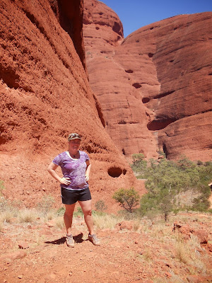
Hiking in Kata Tjuta


Seeing as the desert is so massively huge, a lot of time is spent driving, but luckily our tour guide was funny and prepared which made the time go by fast. We collected firewood in the middle of the bush and spent a good hour picking up sticks so we could have a dinner that night. We spent the evening spotting Fool-uru, the fake Uluru, and yes there is more than one giant rock in the middle of the freaking desert...who would of thought! We watched the sunset over the desert and next to a dry salt lake, it was stunning sight to see and it finally set in that I was in the middle of the Outback. We flew into our camp with our bus like bats out of hell, blaring music and cruising out the middle of nowhere to set up camp. That evening was laughs and giggles as we attempted to cook dinner around our massive camp fire. We spent the night under the starry sky in our 'swags' (sleeping bags with pads), the night sky was crystal clear and it would take you a lifetime to count all of the stars.
Looking up at Uluru
The next day was a jammed packed one beginning with breakfast, camp clean up, and then we headed to Kata Tjuta. This was my favorite day on the tour because this 3 hour hike was through some terrain that I had never seen before. Surrounded by desert was this huge group of these round red rocks towering hundreds of feet above you, and you are able to hike between them as they hover above you. They look smooth as butter from afar, but up-close you see that they are made of tons of smaller rocks. They've been created by earth plates shifting and eroded by wind and water, now they look like melting ice cream scoops...or maybe it was just so hot that I wished they were cold and delicious ice cream scoops. One the hike, our tour guide explained some of the Aboriginal stories and also how they used the local plants and such in their every day lives; for example, they made spears out of these one plants and used a certain vine on the end which helped in hunting kangaroos. That afternoon we headed to the information center that explains the Aboriginal significance of Uluru (Ayers Rock - you know that big red rock) as well the cooperation between the Aboriginal community and the Australian government when it comes to the national park and Uluru.  There is some cooperation between the two, but tensions remain because the majority of people involved with Uluru don't want climbing to be possible, but there is still a small group (the Australian tourism section) that wants to keep the option to climb the rock available. Plenty of people have died doing it and the Aboriginals don't want people climbing it, but it still happens.

Aboriginal cave art
Our tour guide, with Uluru in the back
Uluru was absolutely breath taking, especially when we did a 9 kilometer base walk around the entire thing. We were treated with beautiful views of the rock, looking straight up and not being able to see the top, the blue sky with a faint moon, Aboriginal cave art and stories of the legends that the Aboriginals have of the area. I am so happy that I got to go the Outback, it was everything I wanted it to be and an overall fantastic experience.

On the way back to Alice Springs, which is about a 4 hour drive, we stopped at a racing camel farm. Yes, I know, random; Australia has lots of camels. So the option was available to ride them, and what happens to be on my list to do before I die, ride a camel. So I hoped on the camel with another friend and we rode around a bit. It was hilarious and the ride was a lot smoother than I thought it would be (similar but not exactly like riding horses because they have different steps than horses). Camels are pretty cool creatures, and that was only reinforced by the fact that they can survive in a place like the Outback.

Overall the Outback was a memory I won't soon forget and I'd do it all over again! 


My buddy, I called him Ed, although he looks a lot like other people I know


Friday, November 8, 2013

A glowing greeting from New Zealand

        Sweet as!!
A common phrase here in New Zealand, and I can't help but say it when I drive through the beautiful countryside of New Zealand. This is some of the most beautiful landscape I've ever seen, and some of the nicest and friendliest people I've met abroad.

I left Australia and headed to New Zealand to meet up with 4 friends from my university, we've rented a camper van (company name "Jucy".... uuuhhh) and we've been road trippin' through New Zealand's north island for almost 2 weeks now.

The city of Auckland was nothing of great importance, a standard city with some nice buildings and walks. But, what New Zealand is known for is their natural beauty....and we soon experienced it as we left the outskirts of the city. Rolling green hills, sheep everywhere, mountains in the back, and small towns in the middle of nowhere.

We headed from Auckland to Waitomo, and 3 hour drive. One lovely thing about driving around NZ is the short distances and drastic changes in landscape. In just 3 hours, we went from a city by the sea to Lord of the Rings-esque landscape with a huge system of underground caves below and pastoral landscape above. My Danish friend and I decided to explore the caves in an adventurous style; we went on a tour with a few other people that took us through the caves. We grabbed inner tubes and hiked into the ground; we were rewarded with the entire ceiling of these caves being covered in bright glow worms. It was a beautiful sight to see as we floated down the underground river looking up at the milky way of glow worms covering the cave ceiling. The pitch black caves had some surprises, we had to slide down a waterfall and jump off another - in pitch dark, it was quite the adrenaline rush. The cave was also full of stalactites and stalagmites, and unfortunately we weren't able to take pictures in the cave because it affects the glow of the worms, so I've uploaded some that represent what it looks like.


The milky way like stream of glow worms was a magnificent sight, nothing like anything I've ever seen.

Other natural wonders of New Zealand include natural hot springs in the Rotorua area (a geothermal hot spot). We found a local spot just south of Maori land (Maori is the local indigenous culture), it was a beautiful natural hot spring that also had mud. Uniquely, this river ran right into a cold stream from the other direction, so depending on where you were standing, you could be in hot, cold, or warm water. It was fantastic, and the natural mud facial was an added bonus!

The adventures and beauty of New Zealand continue to amaze me, but seeing as we are road trippin', internet access is limited at best so unfortunately I won't be able to update everyone too often.
Life is good!